Making Sense of Hurricane Sandy?

Image from NASA

There is no better time for this. We are just starting the topic of hurricanes and severe weather in our “EES 113: Natural Hazards and Natural Disasters” class and we got a perfect storm for case study.  Following are some resources that has been compiled to help understand why hurricane Sandy is so powerful and so feared.

  1. How do hurricanes form? – a nice BBC video clip that explains the basics
  2. Hurricane Sandy from Space – Incredible time-series animations of evolution of Sandy from Wired Science
  3. Full moon and Frankenstorm – how moon affects storm surge?
  4. Live – Hurricane track with various hazards marked map
  5. Why Sandy is so dangerous (nice video that goes over good details)
  6. Havoc as storms come ashore – NYT article with lots of photos
  7. Map showing wind speeds along Sandy’s path
  8. NPR News – All things considered
  9. Science of Sandy (NPR piece, not really science that you may be looking for)
  10. Hurricane Sandy and Climate Change – nice article from Huffington Post
  11. Hurricane Sandy swallows presidential campaign
  12. Sandy’s impact on election is uncertain
  13. Obama and Romney respond to Sandy
  14. New York State – a declared major disaster area

Feel free to contact Dr. Suresh Muthukrishnan with any questions or comments.
75th Anniversary Meeting of the Carolina Geological Society held in Greenville

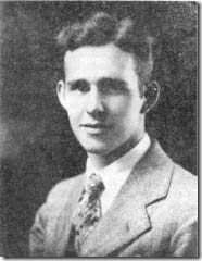
HollandPhoto to the left: Wilbur C. Holland circa 1930, founding father of the Carolina Geological Society.

It was 75 years ago, in 1937, that Wilbur C. Holland, then Geology Professor at Furman University, founded the Carolina Geological Society (CGS) to create an active community of geologists in the area. The main purpose of the society is to promote the Geosciences, encourage the study of Earth Science, promote spirit of friendship and cooperation, and encourage research and publication. At the time of its founding, Holland envisioned a full day meeting with presentations of papers in a morning session and field trip in the afternoon. Currently, the meeting is held over three days, starting with a reception on the first evening, followed by a day and a half of field trips to various localities.

As a tribute to the 75th anniversary of CGS, Furman Earth and Environmental Sciences professors Dr. Bill Ranson, Dr. Jack Garihan, and Dr. Suresh Muthukrishnan conducted the meeting in Greenville. Field trips showcased the geology, geomorphology and landslide hazards in Upstate of South Carolina. A special celebration was held at the Table Rock State Park Pavilion on Saturday evening.

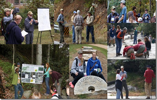
Collages

Students Brooks Bailey, Claire Campbell, Stephen Campbell, Katharine Compton, Elizabeth Johnston, and Ryan Richardson assisted the leaders during the planning stages and during the field trips, ensuring the safety of participants along congested roadways. Apart from these student assistants, 15 other Furman students attended the conference. A total of 156 total participants were present making it a successful event. The edited volume of the field guide in electronic format will be available from CGS website.

2012-10-14_CGS Meeting

The department wishes to thank all the student assistants and especially Ms. Nina Anthony for their tireless efforts and help over the last several months. We also thank our recent graduate Jay Bridgeman (‘12) for leading a part of the field trip to the Salem ultramafic body on Saturday.

Click here for photos from Carolina Geological Society annual meeting, 12-14, October 2012, Greenville, South Carolina.

Jay Bridgeman’s experience with USGS exploring Mineral and Geothermal Potential

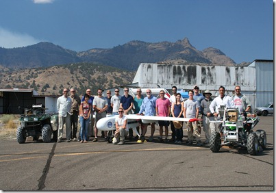
2012_SV_groupJay Bridgeman, 2012 graduate from EES, spent the summer working on an internship with the US Geological Survey western region branch in Menlo Park, CA. He worked with the geophysics unit investigating mineral and geothermal potential in several locations in Nevada, California and Oregon. Jay worked with several geophysical techniques including gravity, magnetic, paleomagnetic and electrical methods to image structures in the subsurface.

He says, “we would spend between 10-15 days in the field locations doing long days of field work, collection and processing of geophysical data, and physical rock property measurements. We even got to do a joint venture with NASA flying a magnetic survey with an unmanned aerial vehicle, which was featured in a Scientific American expedition blog. I really enjoyed my internship with the USGS, and felt that Furman had definitely prepared me and given me the skills necessary to excel.”

Jay is currently working with Unimin Corporation as a Geologist doing core logging and sampling in Wisconsin, Minnesota and a few other Midwest states, primarily with their silica division.

For more information on Jay Bridgeman’s work with USGS, visit the Scientific American blog.