We started our day at 8 AM, and visited Icelandic Meteorological Office who is the main governmental body that oversees weather, climate, seismological, and GPS network in Iceland. We learnt about the current status of scientific observations and monitoring that is going on with respect to the erupting volcano in southern Iceland. After that, Thorleifur took us to "the pearl" building (Oskjuhlid) that has a unique architecture and shape to the building. This building is located on top of a small hill and houses the hot water storage reservoirs and distributes it through pipeline by gravity (without the need for pumping) for the city of Reykjavik. Hot water is piped in from more than 60 km distance where geothermal fields are located. We did a little grocery shopping for lunch, and realized it was as expensive as having a full meal for the group! Everything is expensive here.
Our first field stop was at Hellisheidi Geothermal Power Station located in Orkuveita. This is a really cool facility that generates currently generates about 213 MW of electricity. In comparison, whole of Reykjavik city (population of about 150,000 or half of Iceland) only needs about 200 MW of electricity. This is not the only geothermal power plant in Iceland! We were (not so?) surprised to learn that it cost IKR 10 per KW of electricity and IKR 80 per cubic meter of hot water (currently, $1 = IKR 128). This power plant is very advanced and so they don’t have any waste water lagoon like some of the other ones. Most of the waste water is captured and reused or injected back in to the ground. They are also working on a plan to separate all CO2 from steam, dissolve it in water and pump it back into the ground to reduce natural CO2 emission that comes as part of exploiting geothermal solution. Second stop was at a small town named Hverangerdi for students to exchange currency. One of the restaurants in this town uses geothermal heat to cook and bake goods. It was an amazing site to see the chef coming with a bag full of potatoes and dumping in to hot and steamy water outside the restaurant.
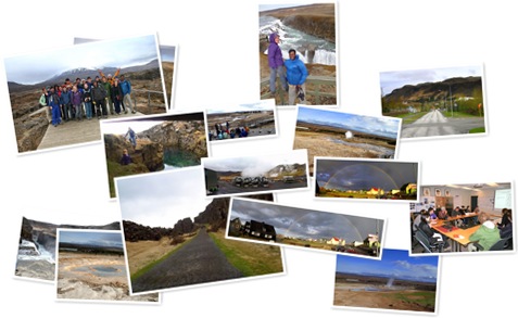
Our next stop was to Þingvellir (Thingvellir) National Park located in the southwestern Iceland. This place is very important to Icelanders historically because this is where they had their parliament was established way back in 1930. Read more interesting information about this park’s history here. Geologically, this site is located in the middle of the rift zone, so it displays the rift valleys and faults with large displacements clearly. One of the faults run for more than 10 miles and is about 20m wall high cliff. There is a large freshwater lake, which is likely the largest freshwater lake in Iceland, located at this park. One of the other coolest thing at this site is Nikulásargjá, which is a rift-fracture with clear, transparent and very deep water with tons of coins thrown in by the visitors. Some of the students tried to put their hand to grab some coins but water was freezing cold, so just managed to pick some coins that were stuck along the shores. The major river that feeds into the lake here is called Öxará. Our guide, a historian, said the name is based on the legend that in ancient times, men and women were punished for their crimes at this site – men were beheaded and women were drowned in the cold waterfall called Öxarárfoss. We had lunch at a picnic shelter that was surrounded by older volcanic mountains, some of them had snow cover on top. From there, we were able to see one of the coolest shield volcano (very low angled volcanic cone like the ones in Hawaii).
Third stop was at Iceland’s famous waterfall Gulfoss. This waterfall was really cool and even though was not the tallest in Iceland, it had unique step-falls feature, a total drop of little more than 100 feet. The geology of the area aids in development of the waterfall here. Over geologic time (we are talking about several millions of years), glacial sediments and lava flows of different periods built the terrain and with the glaciers melting, large volume of water goes through the area with intense faulting developed by the pulling apart of the continent through mid-ocean ridge (rift zone). The rivers find the fault zone to be a plane of weakness and take course through them. Due to differences in the erosional potential of volcanic (harder) and sedimentary (easier) rocks, it creates a deep canyon here. This waterfall is eroding at a rate of about 25m/year (I have to check this number though!). This means, in four years, the location of waterfall would have moved 1 meter upstream from where it is.
The last geological stop for the day was at “The Geyser”, that erupts at about 5-6 minute cycle. As we were approaching the geyser site, we got to witness one of the largest eruption of the geyser from our bus. We spent about an hour there witnessing several geyser eruptions, some of us getting splashed by the erupting geyser. It’s amazing to see the pool of water slowly rocking back and forth until a huge amount of gases and super heated water travel through from the depth and bulging up to become an explosion. Just cool!
Our guide then recommended that we visit a small coastal town called Eyrarbakki, his native town where his grand father was a fisherman long time ago, to see an exhibition at a historic house and visited the local museum. We were treated with some traditional songs by a group of locals at the exhibition house. We also saw an amazing full rainbow as the sun went down in the late evening. One of the best evenings.